The Albion Academy
1 London Street
Salford
M6 6QT
If you live close to your school why not walk, wheel, or cycle? Not only is it a healthy and fun way to travel, but it can be an opportunity to chat with your friends. You can also save money and even time.
Plan your route to school using our online active travel map
Scheduled Bus Services
Scheduled bus services run frequently throughout the day and pass within a short walking distance of the school.
These bus services have stops close to the school:
Cromwell Road, 3 minute walk away
Google Map directions for Cromwell Road bus stop
- 10 - Brookhouse Estate - Lower Broughton - Salford - Shudehill
- 95 - Pendleton - Carr Clough - Prestwich - Whitefield - Unsworth - Bury
Cromwell Road, 6 minute walk away
Google Map directions for Cromwell Road bus stop
- 52 - Failsworth - Moston - Weaste - Eccles - The Trafford Centre
- 93 - Carr Clough - Lower Broughton - Salford - Shudehill
Langley Road South, 4 minute walk away
Google Map directions for Langley Road South bus stop
- 74 - Pendleton - Irlams o th Height - Agecroft circular
- 75 - Pendleton - Agecroft - Irlams o th Height circular
Broad Street, 12 minute walk away
Google Map directions for Broad Street bus stop
- 8 - Bolton - Farnworth - Pendlebury - Salford - Shudehill
- 35 - Bryn - Golborne - Leigh - Salford - Piccadilly Gardens
- 36 - Piccadilly Gardens - Salford - Peel - Great Lever - Bolton
- 37 - Bolton - Farnworth - Swinton - Salford - Piccadilly Gardens
- 38 - Logistics North - Swinton - Salford - Piccadilly Gardens
- 50 - East Didsbury - Burnage - Birchfields - Salford - The Lowry
- V1 - Leigh - Tyldesley - Salford - Manchester Royal Infirmary
- V2 - Atherton - Tyldesley - Salford - Manchester Royal Infirmary
- V4 - Ellenbrook - Deans - Salford - Manchester Royal Infirmary
Salford Shopping Centre, 16 minute walk away
Google Map directions for Salford Shopping Centre
- Bus services: 8, 10, 35, 36, 37, 38, 50, 52, 53, 67, 67A, 70, 74, 75, 79, 95, 100
Download the Bee Network app for live departure times for bus, tram and train, including the bus services above.
The nearest train station is Salford Crescent, a 20 minute walk away from the school.

Tickets and passes
Whether it's an igo card, Our Pass, Scholar's Permit, Free School Pass or the Care Leavers travel offer, there are plenty of different tickets and passes to get to school.
Find out how to register for your pass, the costs, benefits and what you need to do if you lose your pass.
-
 Learn more about distractions when driving
Touch. Screen.
Don't touch your phone while driving. It's a dangerous, criminal offence.
-
 Learn more about the Bee Network
Say yellow to the Bee Network
Buses in Oldham, Rochdale and parts of Bury, Salford and north Manchester joined the Bee Network on 24 March.
-
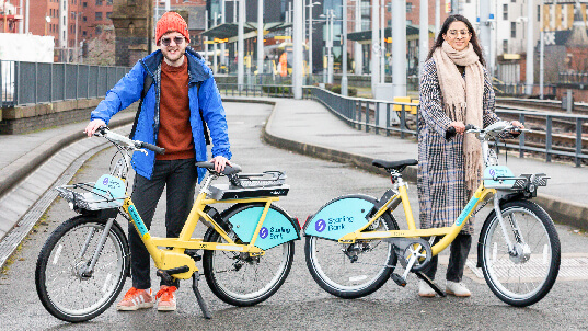 Learn more about new Starling Bank Bikes
New sponsor: Starling Bank Bikes
We’re delighted to welcome Starling Bank on board as the new sponsors of our bike hire scheme.
-
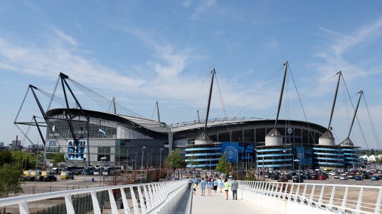 Find full details of the bus routes, ticket fares and timetables
Manchester City Matchday Buses
We've teamed up with Manchester City to launch a large-scale bus trial helping fans from across Greater Manchester and nearby areas to travel to and from the Etihad Stadium on a matchday.
-
 Rate your journey
Rate your journey
We want to hear your views to help us deliver a better Bee Network for Greater Manchester.
-
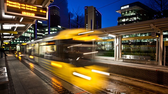 Find out about planned works on the tram
Planned engineering works on Metrolink
Visit our dedicated webpage to find out how the works could affect your journeys.


-
Learn more about distractions when driving
Touch. Screen.
Don't touch your phone while driving. It's a dangerous, criminal offence.
-
Learn more about new Starling Bank Bikes
New sponsor: Starling Bank Bikes
We’re delighted to welcome Starling Bank on board as the new sponsors of our bike hire scheme.
-
Rate your journey
Rate your journey
We want to hear your views to help us deliver a better Bee Network for Greater Manchester.
-
Learn more about the Bee Network
Say yellow to the Bee Network
Buses in Oldham, Rochdale and parts of Bury, Salford and north Manchester joined the Bee Network on 24 March.
-
Find full details of the bus routes, ticket fares and timetables
Manchester City Matchday Buses
We've teamed up with Manchester City to launch a large-scale bus trial helping fans from across Greater Manchester and nearby areas to travel to and from the Etihad Stadium on a matchday.
-
Find out about planned works on the tram
Planned engineering works on Metrolink
Visit our dedicated webpage to find out how the works could affect your journeys.